
Precision Agriculture Services
Precision Data Management is the main core activity here at Environmental & Cropping Technologies Australia, offering a full-service package that includes soil, mapping & data processing solutions.
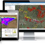
Utilising advanced software, we have the ability to import most machine data files & raw data file formats. After cleaning data files, removing error points and processing, we then have the ability to export processed data into a range of file formats including Shape Files, Google Earth Files, Comma-Separated (.csv) files, Machinery Ready Files and Basic Images.
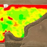
Our software has the ability to process a wealth of information, ranging from yield maps, NDVI biomass maps, elevation & water flow mapping, application (as-applied) maps, variable rate maps & electromagnetic survey … and unlike some of our competitors, we’re proud to do it in-house & not outsource or distribute your work to external companies!

Available services:
Low cost yield data processing with harvester matching services available. No matter what colour you have or brand your screen is, we are able to process your yield data into quality maps to help make informed decisions from.
.
We can assist you with all of your elevation requirements, and create elevation maps, contour maps, watershed maps and ponding maps all in-house. Let us help maximise your on-farm productivity.
.
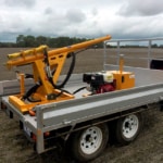
From Deep-N Sampling or full soil nutrient analysis, to depth-to-clay measurements & mapping, we’ve got a sampling solution to help boost your farm nutrient productivity!
Is your equipment VR ready, but you’re just not sure how to get started? Maybe you need some assistance with creating management zones, or combining your data to maximise your potential? Environmental & Cropping Technologies Australia can assist you with all of your VR requirements from start to finish.
Do you have raw biomass imagery that needs processing? Maybe you need satellite imagery sourced and converted into management zones for investigation? We can process your data for you, absolutely pain-free!
Have you implemented Variable Rate (VR) technology in your enterprise, and want to keep a record of actual application rates, speed and/or productivity? Environmental & Cropping Technologies Australia can undertake full Post Task Analysis of your operations, and ensure your records are up to date.